Vermont’s hikes offer a blend of rugged mountain climbs, peaceful woods, and lakeside views, making it a favorite for outdoor enthusiasts year-round.
Camel’s Hump (Camel’s Hump State Park)
Hiking Camel’s Hump State Park is one of Vermont’s most iconic outdoor experiences, offering a challenging climb rewarded with sweeping alpine views. Camel’s Hump, the state’s third-highest peak, is instantly recognizable by its distinct profile and sits along the spine of the Green Mountains. Trails approach the summit from several directions, with the Burrows Trail being the most popular, steadily ascending through dense hardwood forests before transitioning into boreal evergreens. The sense of elevation gain is constant, making this hike feel like a true mountain ascent rather than a casual walk in the woods.
As you climb higher, the forest thins and gives way to a rare alpine tundra ecosystem near the summit. This fragile zone is home to hardy, low-growing plants adapted to harsh winds, thin soils, and cold temperatures, and hikers are carefully routed across exposed rock to protect it. The final approach is rocky and steep, demanding sure footing and attention, especially in wet or icy conditions. Weather can change quickly at this elevation, adding an element of seriousness to the hike that reinforces Camel’s Hump’s reputation as one of Vermont’s more demanding day hikes..
Reaching the summit is a memorable payoff, with unobstructed 360-degree views stretching across Lake Champlain, the Adirondack Mountains of New York, and deep into Vermont’s rolling Green Mountains. On clear days, the panorama feels expansive and wild, making the effort of the climb more than worthwhile. Whether tackled as a strenuous day hike or as part of a longer backcountry adventure with nearby shelters, Camel’s Hump delivers a classic New England mountain experience—rugged, scenic, and deeply rewarding for hikers seeking both challenge and beauty.
Mount Mansfield via Sunset Ridge Trail (Underhill State Park)
Hiking Mount Mansfield via the Sunset Ridge Trail from Underhill State Park is one of the most scenic and rewarding routes to Vermont’s highest peak. The trail begins with a gentle climb through classic Green Mountain hardwood forest, following old woods roads and well-graded paths that make the early miles approachable despite the overall elevation gain. As you ascend, the forest gradually transitions to spruce and fir, and the sense of height becomes more apparent. The steady climb offers a good balance of effort and enjoyment, making this route popular with hikers who want a challenging but not overly technical ascent..
Midway up, Sunset Ridge truly earns its name as the trail emerges from the trees and follows an open ridgeline toward the summit. Long stretches of exposed rock provide increasingly expansive views across northern Vermont, with Lake Champlain and the Adirondacks often visible on clear days. This open terrain allows hikers to experience Mount Mansfield’s dramatic scale well before reaching the top, but it also means exposure to wind and rapidly changing weather. The footing becomes rockier and more uneven, requiring careful steps, especially in wet, snowy, or icy conditions common at higher elevations..
The final push connects to the summit ridge of Mount Mansfield, where hikers encounter the mountain’s famous alpine zone—one of the largest and most fragile in the eastern United States. Wooden walkways and marked paths help protect the delicate tundra while guiding hikers along the ridge past features named for parts of a human face. From the summit area, sweeping 360-degree views stretch across Vermont, New York, and even into Canada on exceptionally clear days. Hiking Sunset Ridge to Mount Mansfield delivers a quintessential Vermont mountain experience, combining forest solitude, dramatic open ridgelines, and a truly spectacular alpine summit.
Sterling Pond Trail (Smugglers' Notch)
Hiking the Sterling Pond Trail in Smugglers' Notch is a short but rewarding adventure that packs classic Green Mountain scenery into a relatively compact outing. The trailhead sits high in the Notch, immediately immersing hikers in steep rock walls, cool mountain air, and dense spruce–fir forest. From the start, the path climbs steadily, crossing rocky steps, roots, and small streamlets that add character without being overly technical. Its moderate length makes it accessible to a wide range of hikers while still feeling like a true mountain trail.
As you ascend, the forest canopy occasionally opens to reveal dramatic cliffs and talus slopes that define Smugglers’ Notch. The sound of wind moving through the trees and water trickling over stone creates a quiet, alpine atmosphere, even though the trail is popular during peak seasons. Footing can be uneven and muddy after rain, so sturdy footwear is helpful. In autumn, the surrounding hardwoods light up with vibrant color, while summer offers cool shade and relief from valley heat.
The trail culminates at the shores of Sterling Pond, a serene high-elevation body of water tucked beneath the slopes of Mount Mansfield. Surrounded by evergreens and rocky ridges, the pond feels remote and peaceful, making it an ideal spot to rest, picnic, or simply take in the mountain setting. Reflections of clouds and surrounding peaks shimmer on calm days, enhancing the sense of quiet beauty. The Sterling Pond Trail delivers an excellent introduction to hiking in Smugglers’ Notch—compact, scenic, and deeply satisfying for those seeking a quick escape into Vermont’s high country.
Mount Pisgah (Lake Willoughby area)
Hiking Mount Pisgah in the Lake Willoughby area is one of Vermont’s most dramatic and visually striking day hikes. Rising abruptly above the eastern shore of the lake, Mount Pisgah towers over the narrow, fjord-like valley carved by glaciers. The trail begins near the water’s edge and climbs steeply through mixed hardwood forest, immediately gaining elevation and offering occasional glimpses of the lake below. From the outset, the hike feels bold and vertical, rewarding effort with an increasing sense of exposure and scale.
As the trail ascends, the forest transitions to rocky ledges and short scrambles that demand careful footing, especially after rain. Several lookout points appear before the summit, each offering breathtaking views straight down the sheer cliffs to the deep blue waters of Lake Willoughby. These vantage points are among the most photographed scenes in the Northeast, with Mount Hor rising sharply across the lake to create a dramatic natural corridor. The combination of steep terrain, exposed rock, and sweeping scenery makes this hike feel far more rugged than its mileage suggests.
The summit of Mount Pisgah delivers one of the finest panoramic views in the state. From the top, hikers can see the full length of Lake Willoughby framed by towering cliffs, along with rolling forested hills stretching into the Northeast Kingdom. On clear days, the landscape feels vast and untamed, reinforcing the wild character of the region. Hiking Mount Pisgah is a short but intense experience—steep, scenic, and unforgettable—perfect for hikers seeking dramatic rewards without committing to an all-day trek.
Lye Brook Falls Trail (Green Mountain National Forest)
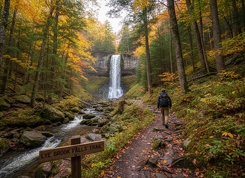
Hiking the Lye Brook Falls Trail in the Green Mountain National Forest offers a peaceful and scenic journey to one of Vermont’s tallest and most impressive waterfalls. The trail begins near the Somerset Reservoir area and follows an old logging road into the heart of the Lye Brook Wilderness. The grade is generally moderate, making it accessible to a wide range of hikers, and the early miles pass through mixed hardwood forest with gentle elevation gain. The setting feels quiet and remote, especially compared to more heavily traveled mountain summits in the region.
As the trail continues deeper into the wilderness, it narrows and becomes more rugged, with roots, rocks, and small stream crossings adding to the sense of immersion in a protected landscape. The forest canopy provides shade in summer, while spring brings rushing water and lush greenery along Lye Brook. Wildlife sightings are possible, and the absence of motorized noise enhances the feeling of solitude. During fall, the trail is especially popular as vibrant foliage transforms the surrounding hillsides into a mosaic of color.
The hike culminates at Lye Brook Falls, where water plunges roughly 125 feet down a sheer rock face into a rocky pool below. The falls are especially dramatic after heavy rains or spring snowmelt, sending mist into the air and filling the forest with sound. A small viewing area allows hikers to rest and take in the scene while respecting the fragile terrain around the base. The Lye Brook Falls Trail delivers a classic Vermont hiking experience—tranquil forest walking paired with a powerful natural reward at the journey’s end.
The Long Trail (Various sections)
Hiking The Long Trail—whether for a single day or across multiple sections—offers an immersive journey through the heart of Vermont’s Green Mountains. Stretching the length of the state from Massachusetts to Canada, the trail provides tremendous variety depending on which segment you choose. Southern sections tend to feature gentler grades, rolling ridgelines, and well-maintained paths, making them approachable for day hikers and newer backpackers. These lower elevations still deliver classic New England forest scenery, with hardwoods, quiet streams, and frequent trailheads that allow for flexible planning.
Moving north, the Long Trail becomes progressively more rugged and demanding, often sharing its tread with the Appalachian Trail before diverging into steeper, more remote terrain. Northern sections are known for rocky footing, exposed ridges, ladders, and scrambling, particularly around peaks like Camel’s Hump and Mount Mansfield. These areas showcase some of the East’s most extensive alpine zones, where hikers walk above treeline amid hardy tundra plants and sweeping mountain views. Weather can change rapidly, and the terrain rewards preparation, patience, and solid hiking experience.
Across its length, the Long Trail is supported by a network of shelters, campsites, and side trails that make both short and extended hikes possible. Day hikers might target scenic stretches to waterfalls, summits, or ridgelines, while section hikers and thru-hikers experience a deeper rhythm shaped by terrain, weather, and solitude. Whether explored in small portions or ambitious multi-day segments, hiking the Long Trail delivers a quintessential Vermont experience—wild, challenging, and deeply connected to the landscape of the Green Mountains.
Mount Abraham via Lincoln Gap
Hiking Mount Abraham via Lincoln Gap is one of the most direct and rewarding routes to this prominent peak in Vermont’s Green Mountains. The trailhead sits at Lincoln Gap, one of the highest drivable mountain passes in the state, allowing hikers to begin at an already lofty elevation. From the start, the Long Trail–based route climbs steadily through dense spruce and fir forest, quickly gaining height and delivering a true high-country feel without a long approach. The climb is relatively short but sustained, making it a popular choice for hikers seeking big scenery in a compact outing.
As the trail ascends, it becomes rockier and more exposed, with sections that feel steep and rugged underfoot. Tree cover gradually thins, and hikers begin to experience open ridgeline walking as they near the summit. Wind is common here, and weather can shift rapidly, reinforcing the alpine character of the hike. The transition from forest to open rock highlights Mount Abraham’s elevation and isolation, offering early glimpses of the surrounding peaks and valleys.
The summit of Mount Abraham is broad, rocky, and unforgettable, featuring one of the finest alpine panoramas in the state. From the top, hikers enjoy sweeping views of the Green Mountains, including close-up perspectives of Mount Ellen, Camel’s Hump, and Mount Mansfield on clear days. The exposed summit feels expansive and wild, making it an ideal place to linger—conditions permitting—and take in the vast landscape. Hiking Mount Abraham via Lincoln Gap delivers a classic Vermont experience: short, steep, and spectacular, with alpine rewards that rival much longer climbs.
Deer Leap Trail (Killington area)
Hiking the Deer Leap Trail in the Killington area is a short but dramatic outing that delivers one of central Vermont’s most impressive viewpoints. The trail begins near the Inn at Long Trail and quickly ascends through mixed hardwood forest, climbing steadily but never feeling overwhelming. Despite its relatively modest length, the elevation gain is noticeable, giving the hike a sense of accomplishment early on. The forested setting provides shade and a peaceful atmosphere, making this trail a popular choice for hikers looking for big scenery without an all-day commitment.
As the trail climbs, rocky sections and roots add a bit of rugged character, especially after rain. The ascent builds anticipation for the payoff ahead, with subtle openings in the trees hinting at the views to come. Near the top, the forest thins and the terrain becomes more exposed, signaling the approach to the overlook. The combination of manageable difficulty and dramatic terrain makes Deer Leap appealing to both newer hikers and seasoned outdoors enthusiasts.
The trail’s highlight is the exposed cliff overlook, where hikers are rewarded with sweeping views of Killington Peak, Pico Mountain, and the surrounding Green Mountains. The sheer drop below the viewpoint adds a sense of scale and excitement, making it a memorable place to pause and take in the landscape. On clear days, the panorama stretches across valleys and ridgelines, showcasing the rugged beauty of the region. Hiking the Deer Leap Trail is a classic Killington-area experience—brief, scenic, and immensely satisfying for those seeking a powerful view in a compact hike.
Hogback Mountain (Marlboro)
Hiking Hogback Mountain near Marlboro offers a quieter, more contemplative Vermont hiking experience, well known for its sweeping views rather than long mileage. The trailhead begins off a rural road and climbs steadily through mixed hardwood forest, with a moderate grade that makes the hike approachable for most hikers. As you ascend, the forest is open and airy, especially in spring and fall, allowing filtered light and occasional glimpses of the surrounding countryside. The trail is well defined and peaceful, often far less crowded than higher-profile Green Mountain peaks.
The ascent continues through increasingly rocky terrain as the summit nears, with sections that feel steeper but remain manageable. Historically, Hogback Mountain was home to a fire tower, and remnants of the cleared summit area give the hike a unique character compared to more densely wooded peaks. The sense of openness grows as the trees thin, and breezes often signal your approach to the top. While the trail is not long, it provides enough elevation gain to feel rewarding without being exhausting.
The summit of Hogback Mountain delivers expansive views across southern Vermont, including the Green Mountains, the Deerfield River Valley, and, on clear days, distant ranges in New Hampshire and Massachusetts. Open ledges make the summit an excellent place to linger, enjoy a picnic, or watch clouds move across the landscape. Hogback Mountain is especially beautiful during autumn, when fall foliage blankets the hills below in vibrant color. For hikers seeking a scenic, low-key summit with broad views and a relaxed atmosphere, Hogback Mountain is a standout destination in the Marlboro area.
Mount Ascutney Trail (Mount Ascutney State Park)
Hiking the Mount Ascutney Trail in Mount Ascutney State Park offers a classic southern Vermont mountain experience marked by steady climbing and expansive views. The trail begins in hardwood forest and quickly establishes a consistent uphill rhythm, gaining elevation through well-defined switchbacks and rocky stretches. While not overly technical, the ascent is sustained, giving hikers a true sense of climbing a mountain rather than strolling a ridgeline. The forested lower slopes are peaceful and shaded, especially pleasant during warmer months.
As you climb higher, the trail transitions into mixed forest with increasing rock underfoot, and the air often feels cooler and breezier. Occasional openings hint at the views to come, building anticipation for the summit. The terrain can be slick after rain or during shoulder seasons, so careful footing is important. Despite its popularity, the Mount Ascutney Trail retains a backcountry feel, especially on weekdays, making it an appealing choice for hikers who want solitude without extreme remoteness.
The summit of Mount Ascutney rewards the effort with sweeping views over the Connecticut River Valley, rolling farmland, and distant hills stretching into New Hampshire. On clear days, the panorama feels wide and pastoral, contrasting nicely with Vermont’s more rugged alpine peaks. The open summit area is ideal for resting, photography, or simply taking in the scale of the landscape below. Hiking the Mount Ascutney Trail delivers a satisfying blend of physical challenge, forest immersion, and scenic payoff—making it a standout hike in southern Vermont.